Locations: Tateyama-Kurobe Alpine Route
Welcome to the dramatic mountain scenery episode of this week's "Michael Finally Updates His Blog"! This segment will cover the northern flank of my travels, cutting directly through the heart of the Northern Japanese Alps. Geographical refreshments are provided below.


Welcome to the dramatic mountain scenery episode of this week's "Michael Finally Updates His Blog"! This segment will cover the northern flank of my travels, cutting directly through the heart of the Northern Japanese Alps. Geographical refreshments are provided below.
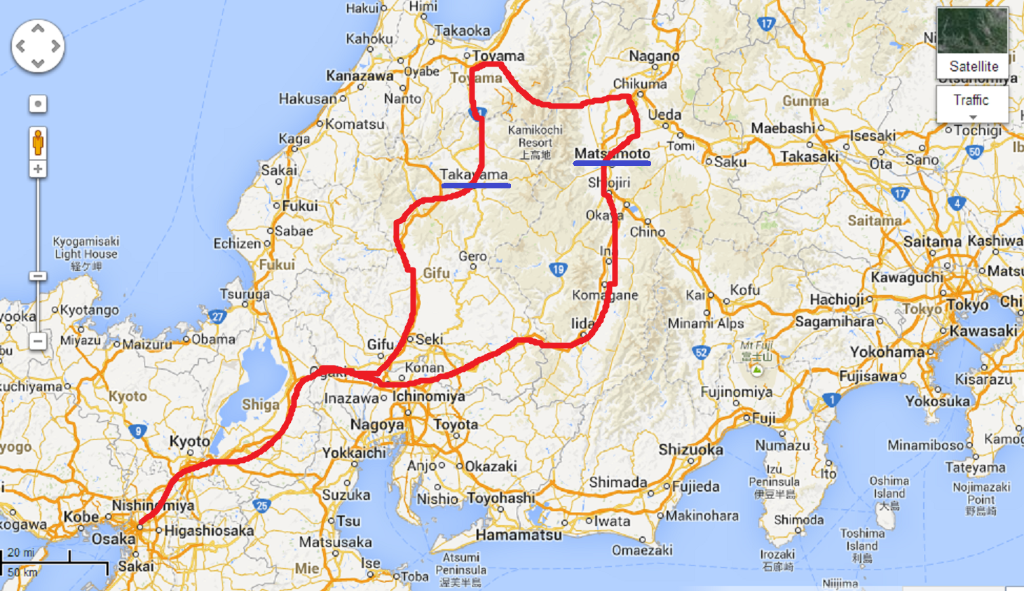
The Tateyama-Kurobe Alpine Route is a series of cable cars, ropeways, buses, and trains that shuttle tourists and mountain climbers from the valley of Tateyama, on the western slopes of the alps, and past the Kurobe gorge, on the eastern side. There's a total of 8 different methods of transportation involved, but luckily most of the rides are less than 30 minutes long, transfers are well-coordinated, and it's easy to buy a general admission ticket for one-way travel across the entire route.
The route is popular since it takes visitors directly into the heart of the dramatic alpine scenery of the Northern Japanese Alps. Instead of hiking for miles up the incredibly steep slopes of the mountains, all it takes is a 1-hour train ride, a short cable car ride, and a 30-minute bus drive to climb over 8,000 feet (2400m) into the one of the highest bus terminals in Japan (second only to a station in the central Japanese alps, situated on a more broad and accommodating mountain plateau).
This day was predicted to be the arrival date of a typhoon in Japan, and forecasts consistently warned of heavy rain to hit the area around 1pm. In order to get the most out of my final sunny hours on the trip, I left Toyama city on the earliest train and arrived at the Murodo bus terminal by 11am, leaving me roughly 2 hours to explore the area. I didn't want to pass through this beautiful mountain range without climbing somewhere to get a good view, so I quickly fast-walked past the crowds of casual tourists and began my ascent of a hiking trail to a mountain hut on the crest of the ridge. The first snows of the season from the previous week hadn't fully melted yet, leaving the mountain slopes a beautiful stitchwork of faded fall colors and brilliant white snow.
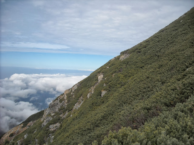
At first, things were looking bright for me. The weather seemed stable, even revealing some blue sky in some places, and I set a brisk pace that rapidly put the bus terminal far in the distance behind me. However, the climb quickly became strenuously steep, and before long I was wheezing and stumbling my way up the trail. To make matters worse, the hut turned out to be higher than I expected, sitting neatly at 3000 meters, over 700 meters above the lowest point on the trail (a total climb of over 2000 feet). An hour and a half into the hike, I finally emerged on the ridge crest just as the typhoon clouds started climbing up the foothills of the mountains, already obscuring the city where I stayed the previous night. I was exhausted and nearly delirious, but the biting cold wind and approaching stormclouds didn't let me relish my conquest for long.
Carefully scrambling down a more direct trail was, of course, much easier than the climb up, but my legs were still pretty badly shaken by the time I descended to the valley floor. The bus terminal was located on the slopes of the opposite side of the valley, so I allowed myself a short rest before delicately resuming my climb at a painfully slow pace. Although the typhoon clouds were almost spilling over into the mountain basin, I wasn't in any hurry to outrun them anymore since I was within a mile of the terminal and no longer traversing dangerous mountain terrain. However, a new force of nature suddenly emerged to speed me along the way.
A short distance downhill from the trail was an active fumarole valley, spewing large clouds of volcanic gas into the air and filling the valley floor with the stench of sulfur. The trails closer to the valley were closed off due to the hazardous concentrations of gas, and generally the gas clouds didn't reach anywhere close to the trail, save for one short wind corridor specifically marked as a hazard zone. Just as I was inching forward through this zone on shaky and strengthless legs, a gust of typhoon wind blew up the mountain simultaneously as the fumaroles released an unusually large cloud of gases. It was almost as if I timed my arrival to the second; the gas cloud blew through the narrow wind corridor just as I was crossing the most exposed hundred yards or so, causing instant stinging in my eyes and lungs. I was absolutely exhausted, but I had no choice but to accelerate my stumbling pace up the trail, hiding my face in my jacket. It didn't smell much despite the acute stinging, which leads me to believe that there were high concentrations of H2S (hydrogen sulfude), but not SO2 (sulfur dioxide). This was good news, in a sense, since the latter is potentially carcinogenic, while the former only has acute effects (it's basically breathing in acidic air; damaging, but not usually in a way that's long-lasting or difficult to notice). I emerged back into fresh air within a minute or two and felt no aftereffects, and soon I was happily sprawled out in the waiting room of the bus terminal.
The rest of my trip passed relatively uneventfully. The scenery was fantastic, but I'll let my (mediocre quality) photos do the rest of the describing. Although it became overcast soon after I reached the bus terminal, it actually didn't start raining until a day later. I guess I didn't need to rush as much as I did. Oh well!
I arrived late that evening in Matsumoto, where I stayed in a more modern ryokan on the outskirts of the city. Not much else left to tell, since I was completely drained of energy for the rest of the day and immediately fell asleep once I settled into my room! Japanese mountain adventure, success!
The route is popular since it takes visitors directly into the heart of the dramatic alpine scenery of the Northern Japanese Alps. Instead of hiking for miles up the incredibly steep slopes of the mountains, all it takes is a 1-hour train ride, a short cable car ride, and a 30-minute bus drive to climb over 8,000 feet (2400m) into the one of the highest bus terminals in Japan (second only to a station in the central Japanese alps, situated on a more broad and accommodating mountain plateau).
This day was predicted to be the arrival date of a typhoon in Japan, and forecasts consistently warned of heavy rain to hit the area around 1pm. In order to get the most out of my final sunny hours on the trip, I left Toyama city on the earliest train and arrived at the Murodo bus terminal by 11am, leaving me roughly 2 hours to explore the area. I didn't want to pass through this beautiful mountain range without climbing somewhere to get a good view, so I quickly fast-walked past the crowds of casual tourists and began my ascent of a hiking trail to a mountain hut on the crest of the ridge. The first snows of the season from the previous week hadn't fully melted yet, leaving the mountain slopes a beautiful stitchwork of faded fall colors and brilliant white snow.
At first, things were looking bright for me. The weather seemed stable, even revealing some blue sky in some places, and I set a brisk pace that rapidly put the bus terminal far in the distance behind me. However, the climb quickly became strenuously steep, and before long I was wheezing and stumbling my way up the trail. To make matters worse, the hut turned out to be higher than I expected, sitting neatly at 3000 meters, over 700 meters above the lowest point on the trail (a total climb of over 2000 feet). An hour and a half into the hike, I finally emerged on the ridge crest just as the typhoon clouds started climbing up the foothills of the mountains, already obscuring the city where I stayed the previous night. I was exhausted and nearly delirious, but the biting cold wind and approaching stormclouds didn't let me relish my conquest for long.
Carefully scrambling down a more direct trail was, of course, much easier than the climb up, but my legs were still pretty badly shaken by the time I descended to the valley floor. The bus terminal was located on the slopes of the opposite side of the valley, so I allowed myself a short rest before delicately resuming my climb at a painfully slow pace. Although the typhoon clouds were almost spilling over into the mountain basin, I wasn't in any hurry to outrun them anymore since I was within a mile of the terminal and no longer traversing dangerous mountain terrain. However, a new force of nature suddenly emerged to speed me along the way.
A short distance downhill from the trail was an active fumarole valley, spewing large clouds of volcanic gas into the air and filling the valley floor with the stench of sulfur. The trails closer to the valley were closed off due to the hazardous concentrations of gas, and generally the gas clouds didn't reach anywhere close to the trail, save for one short wind corridor specifically marked as a hazard zone. Just as I was inching forward through this zone on shaky and strengthless legs, a gust of typhoon wind blew up the mountain simultaneously as the fumaroles released an unusually large cloud of gases. It was almost as if I timed my arrival to the second; the gas cloud blew through the narrow wind corridor just as I was crossing the most exposed hundred yards or so, causing instant stinging in my eyes and lungs. I was absolutely exhausted, but I had no choice but to accelerate my stumbling pace up the trail, hiding my face in my jacket. It didn't smell much despite the acute stinging, which leads me to believe that there were high concentrations of H2S (hydrogen sulfude), but not SO2 (sulfur dioxide). This was good news, in a sense, since the latter is potentially carcinogenic, while the former only has acute effects (it's basically breathing in acidic air; damaging, but not usually in a way that's long-lasting or difficult to notice). I emerged back into fresh air within a minute or two and felt no aftereffects, and soon I was happily sprawled out in the waiting room of the bus terminal.
The rest of my trip passed relatively uneventfully. The scenery was fantastic, but I'll let my (mediocre quality) photos do the rest of the describing. Although it became overcast soon after I reached the bus terminal, it actually didn't start raining until a day later. I guess I didn't need to rush as much as I did. Oh well!
I arrived late that evening in Matsumoto, where I stayed in a more modern ryokan on the outskirts of the city. Not much else left to tell, since I was completely drained of energy for the rest of the day and immediately fell asleep once I settled into my room! Japanese mountain adventure, success!

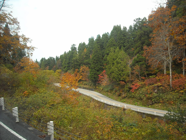
Getting my first taste of fall foliage in Japan as the bus climbs higher into the mountains

Passing above the treeline, into the alpine marshlands of the Midagahara plateau!

Stepping out of the bus terminal at Murodo, the highest point of the alpine route

Yellows, greens, and patches of white blanket this highland landscape above the clouds

One of the crater ponds along the trail, looking impossibly cold in this weather

Keeping a safe distance from the "hell valley" of fumaroles just downhill from the main trail

A better look at the greenish-gray fumarole valley, seeming disarmingly calm

"Hey! We're not done with this bridge yet, but in the meantime, here's some plank and string to keep you from falling into frigid glacier runoff. Have fun!"

Crossing wooden planks above marshy soil through a beautiful alpine landscape

Looking back at the powdered north face of the mountain basin

Seeing more pillars of volcanic gas spring up every time I look back...

From the ridge's shoulder, greeted with views of narrow gorges awash with autumn colors at the bottom (where there is still some semblance of warmth)

A spiky, evergreen stairway to heaven

Walking through a little patch of winter close to the summit of the ridge

Conqueror of mountains , defier of typhoons

Approaching typhoon clouds create a dramatic backdrop for the surrounding mountain peaks

Shingeki no stormclouds

Mother nature's chemical warfare!

One last look at the plateau around Murodo, just as the clouds start spilling into the basin

Two cable car rides later, I find myself face to face with creeping clouds once again...

Minas Tirith, except made out of concrete and holding back a lake

Looking out at Kurobe reservoir

The jagged peaks of the alps, which stood eye level to me just hours ago, now loom far overhead

Dramatic fall colors interspersed with evergreen thickets cover the walls of the Kurobe gorge
Thus concludes my adventure through the Nothern Japanese Alps!
No comments:
Post a Comment